


Table of Contents
What is Automatic Vehicle Location (AVL)?
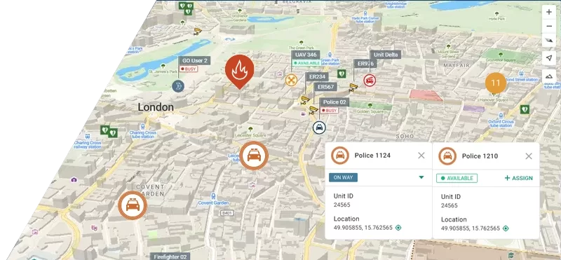
Automatic Vehicle Location (AVL) is a technology used to monitor the real-time location and movement of vehicles and personnel. It integrates satellite navigation systems, such as GPS, or other satellite-based navigation services, and communication networks to transmit the real-time positions of moving units to a command and control center.
AVL software is widely used by organizations managing large fleets or personnel to optimize productivity, safety, and response times. Examples include:
- Law enforcement agencies
- Public safety services (fire and rescue services, emergency medical services – EMS, etc.)
- Ministries of Interior
- Energy companies (oil and gas, mining)
- Humanitarian organizations and NGOs
- Manufacturing companies
In addition to location tracking, advanced AVL software like Tactical AVL offers sophisticated features such as geofencing, user alerts, and integration with field data and video feeds from different sources (such as CCTV).
AVL systems play a crucial role in improving operational efficiency, safety, and responsiveness across a wide range of industries and sectors.
What is the difference between GPS and AVL?
GPS (Global Positioning System) is a global network of satellites developed by the U.S. government that provides location data to receivers anywhere on Earth. While GPS is the most widely-used satellite system in Automatic Vehicle Location (AVL) systems, there are also other similar services such as Galileo, Glonass, BeiDou.
AVL (Automatic Vehicle Location), is a specialized software that leverages GPS technology to monitor and manage vehicles or people in real time.
In essence:
- GPS provides the location data (“where”).
- AVL takes that data and enhances it, offering a user-friendly interface that also integrates other data to improve decision-making and unit management.
AVL software turns simple location tracking into a powerful tool that businesses and agencies can use to improve performance and safety.
What Are the Use Cases of AVL Systems?
Automatic Vehicle Location systems are used for various purposes, with precise location tracking being just one of them.
Real-time tracking
AVL software provides dispatchers and other officers in charge with real-time location data, allowing them to manage field units effectively. This allows them to respond quickly. In other words, take immediate and informed action when an emergency occurs:
- Identify the nearest available unit – AVL systems provide real-time location data for all field units (e.g., police cars, ambulances, fire trucks). Dispatchers can instantly see which unit is closest to the emergency site.
- Send precise instructions – With AVL, dispatchers can direct the nearest unit to the exact location of the emergency (so called (waypointing) using the most efficient route, minimizing response time.
- Monitor the situation in real-time – AVL systems allow dispatchers to track the progress of field units as they respond to an incident, ensuring that help arrives as fast as possible.
For example, AVL systems significantly add to the effective management during disaster emergencies by delivering clear visibility of responding units. This was also a case of the nationwide public safety organization that oversees disaster response operations in the ASEAN region which deployed GINA’s Tactical AVL software. Learn more about this deployment here.
Active localization
When an illegal activity occurs, AVL systems ensure that operators can quickly locate the nearest unit and send it to the scene.
Unit coordination
To protect lives and assets, effective coordination of the units during the incident is of paramount importance. AVL systems give operators full visibility of responding units and allow them to receive information from the scene, facilitating better decision-making and assignment of resources and personnel.
For instance, an oil and gas corporation operating its industrial area in the Gulf of Guinea deployed GINA’s Tactical AVL software, improving response time in 70% of cases and decreasing theft by over 40% in the first year. Read more in our case study.
Routing optimization
By using AVL systems, officers in charge can provide units with the most efficient routes to their destinations, reducing response times and ensuring faster arrival at emergency scenes. Also, AVL systems help mining companies to optimize metrics such as the mining cycle — the entire cycle from loading to unloading and returning to the mining site. They allow calculating whether it can be optimized and if drivers are taking the most efficient routes.
Evidence recording and field reporting
Advanced AVL software such as GINA allows for the collection of geolocated field data, including multimedia, which can be used for analysis, training, and future strategic decision-making. Specific data, such as location data related to the sought object or person, can even support legal proceedings by providing location-based evidence.
Legal compliance
Many companies, typically non-governmental organizations but also companies operating in hazardous environments, are legally required to track their vehicles and personnel. This obligation ensures that they can quickly dispatch staff to address situations and prevent, e.g. environmental damage (often referred to as ‘duty of care’ in the space of non-governmental organizations).
Safety notifications
In hazardous situations, automatic vehicle location systems significantly enhance safety of responding units. They enable rapid notification of first responders about an emerging (dangerous) situation. The operator can designate units, send them a push message like “check in if you’re okay,” and then respond accordingly.
8 Factors When Choosing the Right AVL System
When selecting an Automatic Vehicle Location system, consider the following factors:
Deployment – Search for a solution that fits into your IT environment seamlessly and provides a sufficient level of security/data protection. The best practice regarding the automatic vehicle location platforms is using on-premise or hosted deployments.
Automatic Vehicle Location (AVL) systems can be also delivered as a cloud service. However, such deployment introduces some disadvantages because storing sensitive location data in the cloud can raise security and privacy concerns. Also, they require constant and reliable internet access and may offer limited customization.
For some organizations, cloud-delivered AVL can be a great fit, while for critical services, a high level of privacy and reliability may require an on-premises solution to ensure full control over data and minimize the risk of downtime.
Features – In addition to evaluating core AVL purpose – real-time location tracking – consider additional functionalities such as user alerting, reporting, geofencing, and field data collection to maximize the system’s value.
Scalability – Choose an AVL solution that can easily scale with your fleet or team. Some platforms impose strict limits on the number of active users, while others offer greater flexibility.
Integration capabilities – An AVL system should provide seamless integration with specialized databases, diverse sensors such as EPS fire, H2S for oil & gas, IoT for CO2 monitoring, access control systems, CCTV, and real-time video feeds from drones, vehicles, cameras, and other sources.
Device support – AVL software should be available for the devices and operating systems used by your organization.
User experience – The AVL system should offer an intuitive user interface that is easy to navigate. A user-friendly design reduces training time and helps your team fully leverage the system’s capabilities.
Total cost of ownership – Consider both upfront costs (initial purchase) and ongoing costs like maintenance and updates, and support
AVL system support – Search for a vendor that provides responsive technical support, quality documentation and overall customer-first approach.
Emerging Trends in Automatic Vehicle Location Technology
As technology advances, also Automatic Vehicle Location (AVL) systems are evolving to offer even greater benefits to organizations across industries.
One major trend is the integration of 5G networks with AVL systems. The widespread adoption of 5G is expected to significantly enhance the speed, reliability, and real-time accuracy of AVL data. With faster communication, field units will receive more immediate location updates, enabling quicker responses and better coordination during critical operations such as emergency dispatch or fleet management.
This higher data transfer capacity also supports the integration of more advanced technologies such as augmented reality. Projects aimed at enhancing rescue operations with AR and 5G connectivity are already underway – see this news release by GINA Software.
In addition, AI-driven analytics are being incorporated into AVL software, providing predictive insights that help companies optimize routes, reduce fuel consumption, and perform predictive maintenance on their vehicles. These advancements make AVL systems more powerful, transforming them into essential tools for future operational efficiency.
Conclusion
Automatic Vehicle Location (AVL) systems have become indispensable tools for organizations across various sectors, from public safety and law enforcement to logistics and energy. By integrating real-time location tracking, communication networks, and advanced features like geofencing and data reporting, AVL software enhances operational efficiency, ensures safety, and improves response times in critical situations.
Choosing the right AVL system is crucial, with factors such as scalability, integration capabilities, and user experience playing pivotal roles. Organizations looking to enhance their operations and streamline their workflows can greatly benefit from investing in a robust AVL solution.
If you’re ready to take your operations to the next level, consider exploring GINA’s Tactical AVL software. Please email us at sales@ginasystem.com or book a showcase demo directly to learn more.