


Mapping technology has become a foundational tool for organizations navigating complex, fast-paced environments. By linking data to geography, it transforms raw information into actionable insights that support everything from daily operations to strategic planning.
Table of Contents
Why Location Intelligence Matters
In today’s fast-moving world, location is more than just a dot on the map – it’s a dynamic source of insight. Whether you’re managing a fleet, expanding a business, or planning emergency response, understanding where things are happening can transform how you operate. That’s where Geographic Information Systems (GIS) – a powerful form of mapping technology – comes in.
GIS has become essential in a wide range of industries, helping organizations visualize spatial data, analyze relationships, and make faster, more informed decisions. From strategic planning to on-the-ground action, GIS brings clarity to complexity. It also forms the core of advanced systems like AVL (Automatic Vehicle Location), which depend on real-time, location-based intelligence to function effectively.
What Is GIS and What Can It Do?
GIS is far more than digital maps – it’s a comprehensive framework that combines hardware, software, and data to capture, manage, analyze, and visualize location-based information. By layering real-world data such as traffic conditions, terrain, population density, and infrastructure onto interactive maps, GIS helps users uncover patterns, understand relationships, and make smarter, geographically informed decisions.
Some of the most powerful applications of GIS include:
- Smarter site selection: Choose optimal locations based on travel time, demographics, and nearby infrastructure.
- Efficient routing and logistics: Reduce costs and emissions by adapting routes to real-time conditions.
- Real-time asset tracking: Monitor vehicles, equipment, and infrastructure as they move or change.
- Lifecycle and maintenance planning: Prevent issues before they happen with timely insights.
- Growth forecasting and climate planning: Model future population growth, urban development, or sustainability efforts.
- Emergency response coordination: Respond faster with real-time awareness of evolving situations.
GIS allows you to see not just where things are – but how they interact, and what decisions will deliver the best results.
GIS and AVL: Enhancing Fleet Intelligence with GINA Software
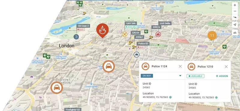
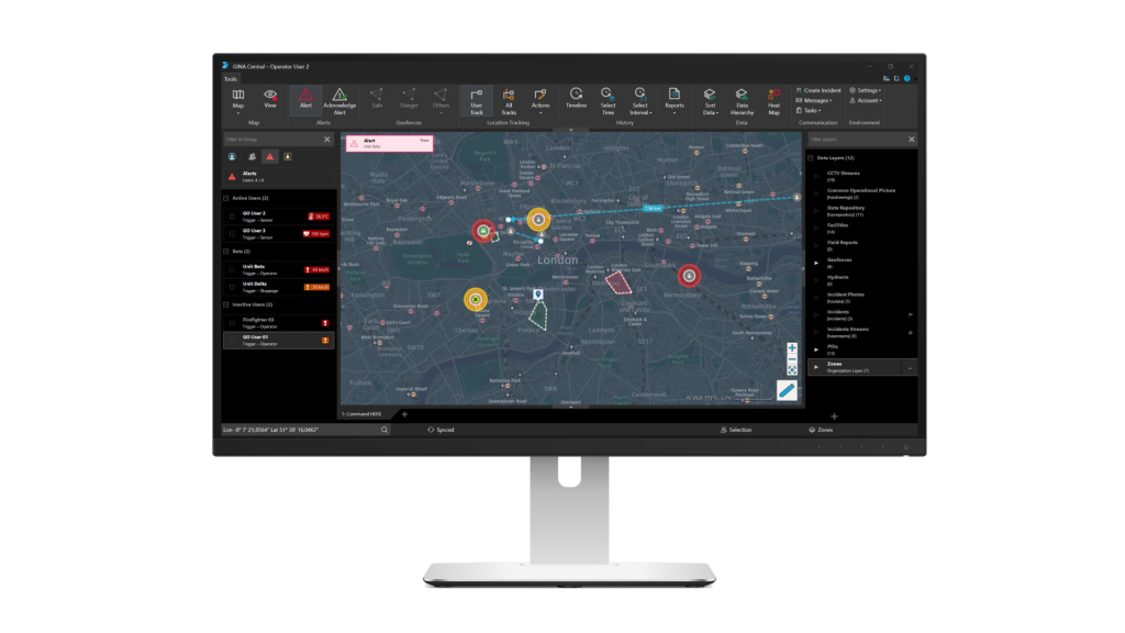
While GIS tells you what’s happening on the map, AVL (Automatic Vehicle Location) brings that map to life with movement. By integrating GIS into AVL systems, organizations can manage their mobile assets with unmatched clarity.
At GINA Software, our Tactical AVL system is built around the strengths of GIS. It doesn’t just track vehicles – it delivers spatial intelligence that enhances safety, efficiency, and responsiveness.
GINA’s AVL solution allows users to:
- Monitor vehicles live on detailed, interactive maps
- Set up geofences for location-based alerts and automation
- Optimize dispatch based on real-time conditions and priorities
- Analyze historical data to improve routing and readiness over time
Whether you’re operating in urban logistics, field services, or emergency response, GIS-powered AVL offers a clear advantage: turning movement into actionable insight.
Smarter Decisions Start with Smarter Maps
GIS has redefined how organizations understand and interact with the world around them. It empowers leaders to act with confidence – planning better, responding faster, and managing smarter. And when GIS is combined with advanced AVL systems like GINA Software’s Tactical AVL, the result is true operational intelligence.
Want to see how location intelligence works in real time? Try the Tactical AVL demo by GINA Software and explore the features firsthand.